Frequency Band and Pedestal for Weather Satellite Receiving System

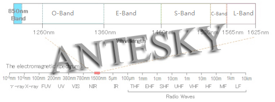
Frequency Band used for Weather Satellite Receiving System include L-band, C-band, Ku-band and Ka-band etc.  The diagram of communication wavelength bands is shown below:   L-Band (1-2 GHz) As a relatively low frequency, the L-band is easier to handle, requires less complex and inexpensive RF devices, and because of the wider beam width, the antenna’s…

History and Development of International Meteorological Satellites

Meteorological satellites are artificial earth satellites that perform meteorological observations of the Earth and its atmosphere from space. The satellite carries a variety of meteorological remote sensors that receive and measure visible, infrared and microwave radiation from the Earth and its atmosphere and convert it into electrical signals for transmission to ground stations which restores…

Meteorological Satellite Application

Meteorological satellites, also called Weather satellite, are mainly used for weather analysis and forecasting, numerical weather prediction, climate monitoring and prediction, ecological and environmental monitoring, especially in the monitoring and warning of severe cyclone and mesoscale severe convective weather, and meteorological satellites can also be used for Earth observation and scientific experimental satellites. The meteorological…

X/Y Mount Antenna for Tracking LEO

The X-Y mount antenna is used to track low earth orbit (LEO) and medium earth orbit (MEO) satellites. This type of antenna eliminates the “keyhole” of the traditional pitch/orientation (El/Az) tracking antenna in the zenith direction, cable winding and backlash problems. These advantages of the X/Y antenna design can now be achieved with very small…

Vertex Tracking with X/Y Pedestal

Vertex tracking: When the satellite passes through the top position of the ground station, that is, the ground station antenna is in the skyward position, the ground station system can track the satellite in a timely and effective manner, and does not lose the target when the roof is over, ensuring the normal transmission of the…

LEO Satellite System for Remote Sensing

Low Earth Orbit(LEO) satellite system with remote sensing generally refers to a satellite system composed of multiple satellites that can perform real-time information processing. The low-orbiting satellite (1000~5000km from the ground) takes a short time around the earth, usually 2~4 hours. With the characteristics of easy to obtain high-resolution images of targets, low-orbit satellites are generally…

Application for Remote Sensing Antenna

Remote sensing is a general term for a comprehensive technical system for observing the Earth and celestial bodies from the ground to the upper air. It consists of remote sensing platform, remote sensing instrument, and information receiving, processing and analysis applications. They provides people with rich scientific data and dynamic intelligence day and night. The…